
Fiber Optic Network Design and Planning
This practical course provides in-depth training in fiber optic communication systems, with a strong focus on Outside Plant (OSP) design, network architecture, and implementation strategies. You’ll gain hands-on knowledge of fiber types, splicing methods, cabling plans, and the essentials of route planning for urban and rural deployments. The curriculum is ideal for those seeking careers in telecom, broadband infrastructure, or utility sectors.
Fundamentals of fiber optics and light transmission
Fiber types, connectors, and cables
Passive Optical Network (PON) architecture
OSP design: trenching, aerial layouts, handholes, cabinets
Fiber route planning using base maps
Fiber splice planning and OTDR basics
Reading and creating OSP design drawings
Permitting, Right of Way (RoW), and field safety
Real-world FTTH (Fiber to the Home) case studies
End-to-end planning of a mock fiber rollout
Aspiring telecom engineers, network planners, field technicians, or civil engineering graduates seeking practical exposure in the fiber optics industry.
By the end of this course, you’ll not only understand how JavaScript works — you’ll be ready to build interactive websites, dynamic applications, and even full-stack projects with confidence.
Lectures
13
Duration
13 weeks
Quizzes
5
Assignments
5
We Train Outstanding Fiber Designers
100k+ Jobs • $50k Starting • Money Back Guarantee
13 Live Classes
Join Live Classes Every Week
5 Real Life Projects
Complete Projects Using Industry Used Tools
Weekly Feedback
Receive Weekly Feedback on Your Work
Job-Ready Portfolio
Build a Job-Ready Portfolio During the Program
Certification of Completion
Graduate with a Fiber Design Certificate
Why is Fiber Designing a Great Career Option?
Longevity • Constant Demand • Flexibility
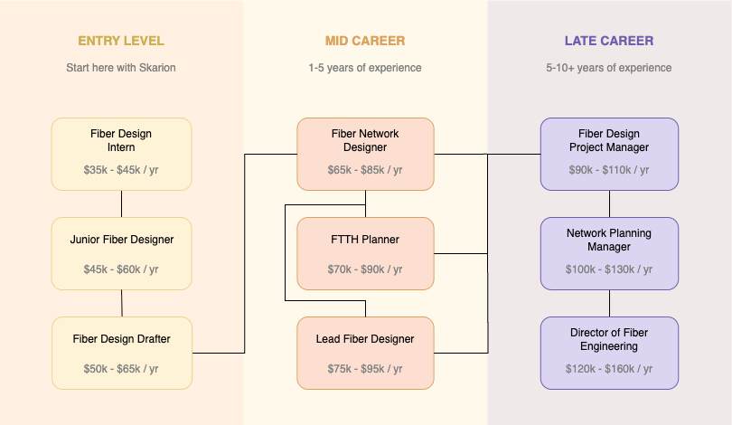
What Do Fiber Designers Do?
A Day in the Life of a Fiber Designer

Emails and Project Updates
Check client emails, field survey reports, and internal design requests.
Review Project Scope and GIS/Survey Data
Study maps, redlines, and survey data to understand the area of design.
Start Designing Fiber Routes
Use AutoCAD, GIS, or network design tools to lay out fiber paths, handholes, and splice points.
Coordinate with Field Team or Project Manager
Clarify site constraints, pole data, or duct availability via Zoom or chat.
Draft Fiber Splice Plans and Cable Schedules
Assign cable sizes, splitters, and splice connections following design standards.
Prepare BOM, Design Notes, and Layout Sheets
Generate bill of materials (BOM), construction notes, and plots for review or permitting.
QA Review or Peer Feedback
Review drawing accuracy, checks alignment with field data, and submit for internal QC.
Organize Files and Log Progress
Update design logs, back up DWG/PDF exports, and wrap up the day.
Course Outline
13 Weeks • 13 Live Classes
Week 1: Introduction to Fiber Optics and Light Transmission
Understand how fiber optics work and the principles of light transmission.
Week 2: Fiber Types, Cables, and Connectors
Learn about single-mode vs. multi-mode, cable structures, and connector types.
Week 3: Passive Optical Network (PON) Fundamentals
Explore PON architecture, split ratios, and how signals are distributed.
Week 4: Overview of OSP Design and Infrastructure
Get introduced to trenching, ducting, aerial placement, handholes, and cabinets.
Week 5: Base Maps and Fiber Route Planning
Use real base maps to plan logical and efficient fiber routes.
Week 6: Splicing Concepts and OTDR Basics
Learn how splicing works and how to interpret OTDR readings.
Week 7: Creating and Reading OSP Design Drawings
Interpret and develop OSP drawings using AutoCAD or similar drafting tools.
Week 8: Permitting, RoW, and Deployment Safety
Understand municipal permits, Right of Way requirements, and field safety protocols.
Week 9: Fiber Distribution and Cabinet Layout Planning
Design layout plans for fiber distribution from cabinets to end users.
Week 10: FTTH Network Design and Case Studies
Study real-world Fiber to the Home projects to understand design logic.
Week 11: End-to-End Planning of a Fiber Rollout
Start planning a full fiber rollout from feeder to last-mile connection.
Week 12: Final Project – Mock Fiber Network Design
Design a complete OSP network based on a given scenario and requirements.
Week 13: Project Presentation and Industry Preparation
Present final designs, receive feedback, and explore career/job application paths.
The Skarion Advantage
We Help People Kickstart Their Careers
Job Guarantee
We don’t win unless you do
Mentorship
Real guidance from real experts
Flexible Learning
Learn anytime, from anywhere
How it Works
The quickest and most affordable way to start a career. No experience or degree required!
Consultation
Begin with a Personalized Assessment
Share your background and goals. We’ll help you identify the most suitable career path and training program based on your current skills and aspirations.
Join an Industry Aligned Bootcamp
Enroll in our hands-on, mentor-led programs designed to equip you with practical, job ready skills in high demand fields such as OSP Design and Telecom.
Enroll & Learn
Build Experience
Develop a Portfolio Through Simulated Projects
Work on guided, real-world simulations that mirror actual job tasks. These projects serve as credible experience for your resume and interviews.
Receive Comprehensive Job Placement Assistance
We support your job search with resume building, interview preparation, and active job applications including submitting on your behalf.