Mastering GIS for Beginners
This beginner-friendly GIS program introduces students to the world of spatial data, mapping, and geospatial analysis. You'll learn how to work with geographic data, create maps, perform spatial queries, and analyze real-world problems using powerful GIS tools like QGIS (open source) and ArcGIS (industry standard). The course is structured around hands-on projects, practical datasets, and real-life scenarios relevant to urban planning, environmental studies, and infrastructure management.
Introduction to GIS concepts and applications
Vector and raster data handling
Coordinate systems and projections
Map design and cartographic principles
Geoprocessing: buffer, clip, intersect, spatial join
Attribute table editing and data management
Creating thematic maps and spatial visualizations
Introduction to geocoding and GPS data integration
Basic remote sensing and image analysis
Final capstone project using real-world GIS data
Beginners with no prior GIS experience, students, urban planners, environmental analysts, or anyone looking to enter the geospatial field.
By the end of this course, you’ll not only understand how JavaScript works — you’ll be ready to build interactive websites, dynamic applications, and even full-stack projects with confidence.
Lectures
13
Duration
13 weeks
Quizzes
5
Assignments
5
We Train Outstanding GIS Specialists
100k+ Jobs • $50k Starting • Money Back Guarantee
13 Live Classes
Join Live Classes Every Week
5 Real Life Projects
Complete GIS Projects Using Industry Used Tools
Weekly Feedback
Receive Weekly Feedback on Your Work
Job-Ready Portfolio
Build a Job-Ready Portfolio During the Program
Certification of Completion
Graduate with a GIS Certificate
Why is GIS a Great Career Option?
Longevity • Constant Demand • Flexibility
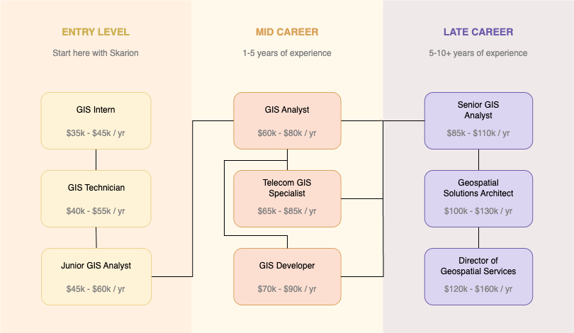
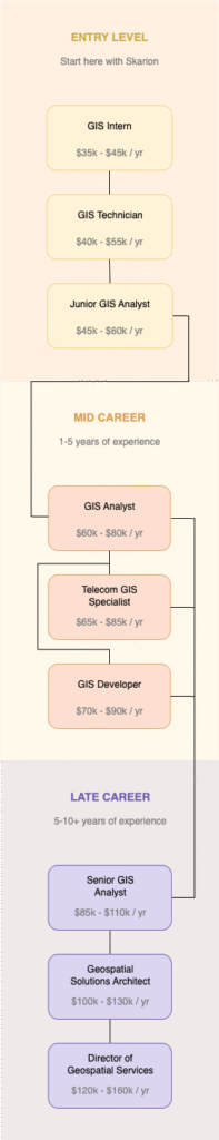
What Do GIS Specialists Do?
A Day in the Life of a GIS Specialist

Check Emails and Project Updates
Start the day by reviewing emails, task assignments, and team communications for new data requests or project updates.
Open GIS Software and Set Up Workspace
Launch tools like ArcGIS Pro or QGIS, load your project files, and organize your layers and folders for the day’s work.
Review and Import Data
Collect spatial and non-spatial data from internal sources, shapefiles, spreadsheets, or web services and import them into your GIS project.
Clean and Preprocess Data
Check for geometry errors, missing attributes, projection mismatches, or duplicates and fix them using geoprocessing tools.
Perform Spatial Analysis
Use tools like buffer, clip, intersect, or spatial join to extract meaningful insights from geographic data depending on the project.
Create and Style Maps
Design clear, readable maps with proper symbology, labels, legends, and scale bars that visualize your data effectively.
Attribute Table Editing
Update or correct attributes in the table to ensure accurate metadata and records for each feature.
Export Maps and Data
Export finished maps as PDFs or images and share datasets in formats like GeoPackage, CSV, or shapefile as needed.
Document Work and Save Versions
Keep a log of tasks performed, tool parameters used, and any assumptions or notes. Save project versions to avoid data loss.
Team Check-in or Supervisor Meeting
Attend brief check-ins or calls with supervisors or teams to review progress, get feedback, and clarify next steps.
Course Outline
13 Weeks • 13 Live Classes
Week 1: Introduction to GIS
What is GIS, how it's used, and its core components — a beginner-friendly foundation.
Week 2: Setting Up Your GIS Workspace
Install QGIS or ArcGIS, explore the interface, and learn how to load and view layers.
Week 3: Coordinate Systems & Projections
Understand how the earth is mapped, and why choosing the right projection matters.
Week 4: Working with Vector Data
Create and edit points, lines, and polygons, and explore how attribute tables store related data.
Week 5: Exploring Raster Data & Imagery
Learn the basics of satellite imagery and elevation data — and how it differs from vector.
Week 6: Finding & Importing GIS Data
Download data from open sources and learn how to bring it into your GIS project.
Week 7: Cleaning & Validating Data
Fix errors in your data like gaps, overlaps, and missing attributes using topology tools.
Week 8: Performing Basic Spatial Analysis
Use tools like buffer, clip, intersect, and dissolve to perform common GIS operations.
Week 9: Styling and Symbolizing Maps
Make your maps beautiful and readable with colors, symbology, labels, and layer styling.
Week 10: Designing a Map Layout
Create a printable map layout with title, legend, scale bar, and north arrow.
Week 11: Geocoding and GPS Data
Turn addresses into points on a map and import GPS tracks from the field.
Week 12: Capstone Mini Project
Apply everything learned to a real-world project, such as mapping infrastructure or population.
Week 13: Final Presentation & Portfolio Tips
Present your project, learn how to export maps, and start building a GIS portfolio.
The Skarion Advantage
We Help People Kickstart Their Careers
Job Guarantee
We don’t win unless you do
Mentorship
Real guidance from real experts
Flexible Learning
Learn anytime, from anywhere
How it Works
The quickest and most affordable way to start a career. No experience or degree required!
Consultation
Begin with a Personalized Assessment
Share your background and goals. We’ll help you identify the most suitable career path and training program based on your current skills and aspirations.
Join an Industry Aligned Bootcamp
Enroll in our hands-on, mentor-led programs designed to equip you with practical, job ready skills in high demand fields such as OSP Design and Telecom.
Enroll & Learn
Build Experience
Develop a Portfolio Through Simulated Projects
Work on guided, real-world simulations that mirror actual job tasks. These projects serve as credible experience for your resume and interviews.
Receive Comprehensive Job Placement Assistance
We support your job search with resume building, interview preparation, and active job applications including submitting on your behalf.